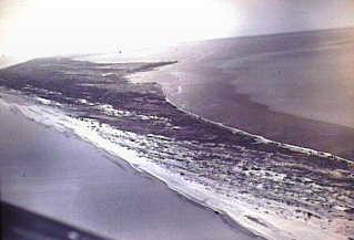
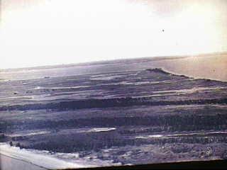
Aerial Views of Long Point
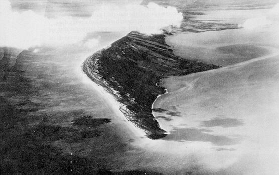
Photo courtesy of Jack Lang
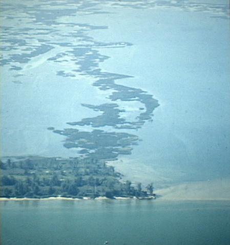
Photo of Pottohawk Point courtesy of George Pond
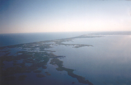
Photo of Pottohawk Point West to Causeway courtesy of Wyatt Goodlet
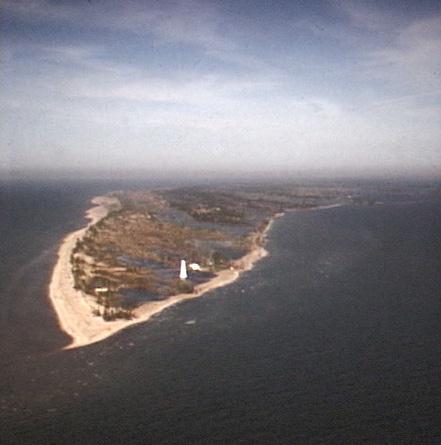
Photo courtesy of George Pond
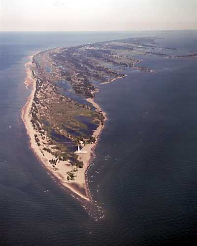
Photo courtesy of Haldimand/Norfolk Development
Photos of Long Point courtesy of Harry B. Barrett
A Flight Lap Along Long Point By Christopher Oxner
The First Survey of Long Point: June 9 to August 12, 1793
William Chewett's Diary
4th July, Sketched in the North Shore of Long Point for about six miles to a point of Rushes in a direct line to a remarkable point of Wood land and sounded across the Bay from the Point of Bushes to John Triers Farm and from thence to our first Encampmant the wind very strong from the S.W.
5th July - At 6 A.M. embarked our Baggage and sketched in the Shore from where we left off to Pottohauk Point the wind blew so hard from the S.W. we could not proceed farther.
6th July - At 6 A.M. the weather being calm embarked our Baggage and sounded from a small Island of Rice about three miles to westward of Turkey Point and from thence back again to Pottohawk Point. We found sufficient depth of water within about a mile or a mile and a half of Turkey Point which induces me to believe we shall find a good Harbour for any vessels that can sail on this Lake. From noon the wind blew so hard from the S.W. that we found it impracticable to examine the Bar from Pottohawk Point to Crown Point it being about five or six miles in length. This day the man who was lame having been ill with a wound in his knee ever since we left Fort Erie.
7th July - Examined the Bar from Pottohawk Point to Turkey Point and the Rushy Islands within about a mile of Turkey Point forming the Entrance of the Harbour and found sufficient depth of water for any vessel to enter. Also sounded along the marsh on the North side leading to the Sand and Clay Hills for two miles and found sufficient depth of water for any vessel to enter the Channel.
8th July - Sounded from the Rushy Islands to [Silas] Secords Farm and from thence to Pottohawk Point. In the afternoon blew a violent storm from S.W. 9th. Sounded from the Rushy Islands to Triers Farm and from thence to Pottohawk Point the wind blowing too hard from the Westward to sound any more this day.
9th July - Sounded from a Point of Rushes to Turkey Point, and from thence attempted to sound the N.E. side of the Bar, that leads from Turkey Point to Pottohawk Point that forms the Harbour. We were blown off to more than the distance of two Leagues, and almost every hand expected to dine with the Fishes or the Fishes to Sup upon us.
Reference: https://sites.google.com/site/longpointsettlers/first-survey
MARSH TOUR
MYSTERY MAP
Back to Harry"B"
Back To

Pagoda Vista
6th July - At 6 A.M. the weather being calm embarked our Baggage and sounded from a small Island of Rice about three miles to westward of Turkey Point and from thence back again to Pottohawk Point. We found sufficient depth of water within about a mile or a mile and a half of Turkey Point which induces me to believe we shall find a good Harbour for any vessels that can sail on this Lake. From noon the wind blew so hard from the S.W. that we found it impracticable to examine the Bar from Pottohawk Point to Crown Point it being about five or six miles in length. This day the man who was lame having been ill with a wound in his knee ever since we left Fort Erie.
7th July - Examined the Bar from Pottohawk Point to Turkey Point and the Rushy Islands within about a mile of Turkey Point forming the Entrance of the Harbour and found sufficient depth of water for any vessel to enter. Also sounded along the marsh on the North side leading to the Sand and Clay Hills for two miles and found sufficient depth of water for any vessel to enter the Channel.
8th July - Sounded from the Rushy Islands to [Silas] Secords Farm and from thence to Pottohawk Point. In the afternoon blew a violent storm from S.W. 9th. Sounded from the Rushy Islands to Triers Farm and from thence to Pottohawk Point the wind blowing too hard from the Westward to sound any more this day.
9th July - Sounded from a Point of Rushes to Turkey Point, and from thence attempted to sound the N.E. side of the Bar, that leads from Turkey Point to Pottohawk Point that forms the Harbour. We were blown off to more than the distance of two Leagues, and almost every hand expected to dine with the Fishes or the Fishes to Sup upon us.
Reference: https://sites.google.com/site/longpointsettlers/first-survey
MARSH TOUR
MYSTERY MAP
Back to Harry"B"
Back To
Pagoda Vista
8th July - Sounded from the Rushy Islands to [Silas] Secords Farm and from thence to Pottohawk Point. In the afternoon blew a violent storm from S.W. 9th. Sounded from the Rushy Islands to Triers Farm and from thence to Pottohawk Point the wind blowing too hard from the Westward to sound any more this day.
9th July - Sounded from a Point of Rushes to Turkey Point, and from thence attempted to sound the N.E. side of the Bar, that leads from Turkey Point to Pottohawk Point that forms the Harbour. We were blown off to more than the distance of two Leagues, and almost every hand expected to dine with the Fishes or the Fishes to Sup upon us.
Reference: https://sites.google.com/site/longpointsettlers/first-survey
MARSH TOUR
MYSTERY MAP
MARSH TOUR
MYSTERY MAP
Back to Harry"B"
Back To
Pagoda Vista